
Introduction
During the Roman conquest of the Iberian Peninsula, the conditioning of transit routes was necessary to facilitate the passage of military troops and thus promote romanization.
Firstly, land routes were modified, with a significant aspect being the reuse of Phoenician-Punic and Greek commercial routes in coastal areas. Once these land routes came under imperial control, Augustus intervened in the creation of the Roman road system in Hispania, parallel to the coastline, to connect terrestrial routes with maritime ones. (Gil Mantas, 2020, p. 499; Chic García, 1990, p. 11).
The land routes, specifically those of Baetica, were constructed according to nearby navigable waterways to connect rivers, roads, and seas as previously mentioned. But why did rivers become a fundamental means of transportation in the Roman world? River transport compared to terrestrial transport was much faster, reliable, and efficient. This is because methods of land-based animal-drawn transport were of poor quality or there was less pulling capacity from mules or oxen.
Table 1. Calculations of carrying capacity in quintals, daily distance traveled in km, and cost of different modes of transportation. Source: (J. Kunow, 1980, p.23).
| Carrying Capacity (quintals) | Daily Distance Traveled (km) | Transport Cost (multiples of maritime transport cost) | |
| BY LAND | 5-6 | 18-20 | 62’5 |
| BY RIVER | 60-140 | 30-40 | 5’9 |
| BY SEA | 600-2000 | 45-65 | 1’0 |
Why were the rivers Guadalquivir and Genil of great importance in Baetica?
The Guadalquivir River originates at «Cañada de Fuentes» (Quesada, Jaén) in Sierra de Cazorla and empties into Sanlúcar de Barrameda. Its hydrographic basin extends through various territories of Spain such as Albacete, Murcia, Badajoz, and Andalusia including Jaén, Granada, Córdoba, Seville, Cádiz, and Huelva with an extension of 57,527 km² and a total length of 657 km. The main tributaries are the Guadajoz River (Córdoba), Guadiato River (Córdoba), Jándula and Guadabullón Rivers (Jaén), Guadalimar River (Albacete) and Genil River (Granada).
The latter, the Genil River, originates in Sierra Nevada from the confluence of water torrents flowing southwest to northwest on the peninsula. Its hydrographic basin is 8,278 km² with a length of 359 km and it is considered the second most important river in Andalusia and seventh largest in Spain. It never runs dry as it fills up both from spring and summer snowmelt and autumn and winter rains (Stuyvesant, 2019).
The Guadalquivir is one of the most important rivers on the Iberian Peninsula due to its great natural wealth and historical significance. Even today, it has little flow at first but as it grows, the waters become calm with a slight slope making navigation possible up to certain areas.
According to Strabo, it was navigable from the sea to Corduba, but ceased being so in the northern part of Castulo; and more specifically, larger ships could navigate as far as Hispalis (Seville), medium-sized ships up to Ilipa (Alcalá del Río) and river boats through Corduba (Córdoba). The significance of the river's navigation lies in its flow and influence, as certain points along the river today do not have sufficient water for it to be navigable (Chic García, 1990, pp. 21-22).
On the other hand, the Genil River or Singilis has not undergone as many changes over time since it is a tributary that grows and shrinks due to being pluvionival, meaning it swells from rain causing overflow mainly in March, April, and May. However, this does not affect the navigability of the river at all; it merely causes flooding affecting nearby areas such as pottery workshops, control points or cities (Chic García, 1990, p. 23).
What specific problems did they face?
In the case of the Guadalquivir River, when it approaches Córdoba its flow decreases making navigation more difficult. The causes are differences in elevation and slopes with the river not following a straight line but rather having variations in course (creating bends and curves) causing landslides and flooding in the area (Chic García, 1990, p. 23).
Today it is impossible to know precisely the ancient route of the Guadalquivir River although we can have an idea based on archaeological findings. In the case of pottery workshops near rivers, they were usually located in high areas to avoid being affected by river flooding. To prevent floods, reinforcements were built along the banks as seen clearly with Ilipa Magna, which due to its proximity to the river had these walls to protect the civitas. Even so, this did not completely save cities or pottery workshops from flooding (Chic García, 1990, pp.23, 26).
The slope was another factor to consider as it affected the speed of water flow and river navigation. It is known that the slope would have been much steeper or pronounced in ancient times (Chic García, 1990, p. 28).
Navigation means:
The flow and speed of the river's waters were different in certain stretches as previously mentioned. This is why various types of boats are used according to the needs of each stretch.
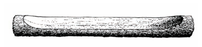
Between Alcalá del Río and Córdoba, medium-sized boats and small single-log boats, monoxylois (see fig.1), were used which became assembled-piece boats after the regulation works. With the evolution of river boats, another type called lyntres, was used in the area of Ilipa Magna. The well-known lynter, linter or lintris is a shallow boat without sails, deck, or keel. Its use was for transporting travelers, animals, and goods in shallower river areas or lakes. In its evolution, it never lost its elongated and narrow shape (Chic García, 1990, pp. 65, 69).

It is also thought that another type of boat for transport would be the rates, which moved with oars, had a flat bottom and could carry large loads. Boats arriving at Hispalis port, the main commercial center of Baetis, were known as corbitae (with a maximum load capacity of 400 tons). Other frequent boats were those called codicariae (see fig.2), made of round wooden planks, with deck and hold, mast in the front part, which could be towed (Chic García, 1990, p. 69).

Conclusion:
In conclusion, land transport is much slower and more expensive since there is less carrying capacity with animal-drawn transport and certain roads or routes were more difficult to traverse. Meanwhile, river transport can advance up to 40 km daily, has a greater carrying capacity, and is much safer for cargo.
In terms of cost comparison, river transport is fifty times cheaper than land transport. As an example, in Baetica the land routes followed the course of the Guadalquivir and Genil rivers to facilitate local product trade by placing most pottery workshops near riverbanks for easier boat access and loading of amphorae with products like wine or olive oil.
River navigation was crucial for transit in Roman territory, playing a fundamental role in the Spanish economy. In the case of Roman Baetica, it turned inland ports into major cities such as Corduba, Hispalis or Astigi.
BIBLIOGRAPHY:
Chic García, G. (1990). “Navigation on the Guadalquivir between Córdoba and Seville in Roman times”. Editorial Gráfica Sol, Écija. University of Sevilla.
Gil Mantas, V. (2020). “The terrestrial, riverine and maritime communication routes of Hispania Romana”, In: Brandao, J.L.; Oliveira, F. (coords.), “History of Ancient Rome Vol II, Empire and Hispanic Romanity”. DOI: https://doi.org/10.14195/978-989-26-1782-4 [20/05/2021]
Remesal Rodríguez (1977). “The Baetica olive oil economy: new forms of analysis”. Spanish Archaeological Journal, 50/51:135/138 (1977/1978)
Stuyvesant, Ernest. (2019). “Guadalquivir River: origin, course, mouth, history.” Lifeder. Retrieved from: https://www.lifeder.com/rio-guadalquivir/ [18/06/2022]


Comments